Plenty of variety on this section of Te Araroa.
Leaving the entirely populated Queenstown the trail rapidly becomes less touristy.
The big, beautiful Lake Wakatipu and its magnificent mountainous backdrop, and the smaller, similarly picturesque Mavora Lakes. Some serious tussock country in the Takitimu Range. Lots of farmland visited via farm tracks. Pine plantations. Native forest. Some gold mining history at Round Hill. Beach walking and views. The final tedious Invercargill to Bluff trudge with 21 km of walking on a highway verge. The iconic signpost at the end of Highway 1, and that Now what? question.
Overall not as relentlessly undulating as some other South Island sections although it does have a few moments. As usual with this trail if there’s a possibility of a hill climb it’s likely you will be up there, but that gives some outstanding views
Not much in the way of additional food supplies from Queenstown to Riverton unless you venture off the trail, still, it’s easy enough to hitch along the highway to Te Anau for a restock.
For those heading south there is the thoughtfulness of ending a long and great experience. For Nobos, those moving north, exuberance about starting.
Variety indeed.
where | Queenstown to Bluff — Te Araroa
Queenstown to Bluff on Te Araroa
click to view larger, more interactive topographic map from, err, topomap.co.nz
distance | Queenstown to Bluff — Te Araroa
324 km Greenstone Track carpark to Bluff, around 5100 m ascent/descent
time | Queenstown to Bluff — Te Araroa
possible in 12 days for energetic hut jumpers, many take about 16
when | Queenstown to Bluff — Te Araroa
November to April inclusive.
maps and GPS | Queenstown to Bluff — Te Araroa
It’s essential to have a paper map in case GPS batteries die.
Most people get by with the generally useful maps and trail notes supplied free for download from the Te Araroa Trust website. These have sufficient detail to find your way. Download and print out your own on a colour laser printer, bubble jet maps don’t survive getting wet at all well. There is a habit of maps being annotated as the track is walked and being passed to those heading in the opposite direction, showing camping site recommendations, etc.
There are also .kmz or .gpx files for free download for your GPS device at the Te Araroa Trust website.
There are Land Information New Zealand, LINZ, Topo50 maps, both digital and paper, but at $7 each they get expensive and some parts of the track cross only small sections of map.
Download free digital versions from LINZ Mapchooser, or buy the real thing, ie, on old fashioned paper, at DOC offices, outdoor shops and bookshops where maps sold. There’s a nationwide list at LINZ Map Retailers.
Need a custom map to print off, or for your GPS device, download a more compact .klm format file from topomap.co.nz for free, although if you download a few maps consider a small donation, there’s considerable work gone into getting that info onto the internet and we should support these useful resources.
route description | Queenstown to Bluff — Te Araroa
People seem to hitchhike from Queenstown as far towards the Greenstone carpark as they can get. You then start the Greenstone-Mavora Walkway before following down the Mararoa River and into the Takitimu Range. Then there is some farmland to traverse and a couple of hills to climb, Woodlaw and Longwood before finally reaching the south coast with some beach walking to get to Invercargill and that last tough day on to Bluff and the finish.
The Te Araroa Trust website has more detailed day-to-day route descriptions, which you can download and print out.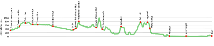
huts and campsites | Queenstown to Bluff — Te Araroa
You will be spending many nights in your tent on this section, not so many huts along the way. There is a distinct lack of official places to stay between Telford campsite and Martins Hut, that’s a big 66 km jump. People seem to cope but finding a suitable campsite with water on that stretch is not easy.
These are the huts and official campsites you are likely to encounter along the way.
Aparima Hut – new | Takitimu Conservation Area
Aparima Hut – old | Takitimu Conservation Area
Boundary Hut | Mavora Lakes Conservation Area
Careys Hut | Mavora Lakes Conservation Area
Greenstone Hut | Greenstone Track/Mavora Walkway
Kiwi Burn Hut | Snowdon Forest Conservation Area
Lower Princhester Hut | Takitimu Conservation Area
Lower Wairaki Hut | Takitimu Conservation Area
Mavora Lakes camping | Mavora Lakes Conservation Area
Martins Hut | Longwood Forest Conservation Area
Taipo Hut | Mavora Lakes Conservation Area
Telford campsite | Takitimu Conservation Area
Tramping times | Queenstown to Bluff — Te Araroa
Here’s the DoC stated tramping times between huts, as shown on their website, usually actual walking times, ie, not taking into account any long breaks. DoC bases its estimation on times for an “average” tramper which means that it’s possible to slash times for more popular sections. With more remote sections the stated time is close to the actual time required.
Some of the times have been taken from the Te Araroa Trust website.
Greenstone Road End to Greenstone Hut
Time: 3-4 hours
Distance: 11 km
Greenstone Hut to Taipo Hut
Time: 4-5 hours
Distance: 10 km
Taipo Hut to Boundary Hut
Time: 3-4 hours
Distance: 12 km
Boundary Hut to Careys Hut
Time: 2 hours
Distance: 6 km
Careys Hut to North Mavora Camping Area
Time: 2 hours
Distance: 10 km
North Mavora Camping Area to State Highway SH 94
Time: 2 days (Kiwi Burn Hut to Lower Princhester Hut is feasible in a big day)
Distance: 47 km
SH 94 to Lower Princhester Hut
Time: 1.5 hours
Distance: 6 km
Lower Princhester Hut to Aparima Hut
Time: 5-6 hours
Distance: 17 km
Aparima Hut to Lower Wairaki Hut
Time: 5-6 hours
Distance: 13.1 km
Lower Wairaki Hut to Telford Campsite
Time: 4 6 hours slower coming north due to big climb
Distance: 8 km
Telford Campsite to Struan Flat Rd
Time: 5 hours
Distance: 18.9 km
Struan Flat Rd to Scotts Gap-Feldwick Rd
Time: 7-8 hours
Distance: 18.2 km
Scotts Gap-Feldwick Rd to Hewitt Rd
Time: 1 hour
Distance: 4 km
Hewitt Rd to Otautau-Tuatapere Rd
Time: 1.5 hours
Distance: 4 km
Otautau-Tuatapere Rd to Merrivale Rd end
Time: 3-4 hours
Distance: 11.1 km
Merrivale Rd end to Bald Hill
Time: 2 hours
Distance: 4.3 km
Bald Hill to Martins Hut
Time: 7 hours
Distance: 16 km
Martins Hut to Round Hill Carpark
Time: 9 hours
Distance: 24 km
Round Hill Carpark to Colac Foreshore Road
Time: 1.5 hours
Distance: 6 km
Colac Foreshore Road to Riverton
Time: 3 hours
Distance: 9 km
Riverton to Invercargill
Time: 8-10 hours
Distance: 31.6 km
Invercargill to end of Highway 1, Bluff
Time: 8-10 hours
Distance: 32.5 km
getting there | Queenstown to Bluff — Te Araroa
Plenty of ways to get to Queenstown and Invercargill, all roads lead there.
Track and Info provides a service to the Greenstone shelter and carpark, past Kinloch, leaving Queenstown at 8 am, Glenorchy 9 15 am, arriving 10 am. Departs Greenstone shelter at 12 noon for return to Queenstown. Cost: Queenstown, $60 adult, $47 child. Glenorchy, $37 adult, $27 child. They also service The Divide, $81 adult, $60 child, leaving Queenstown 6 55 am and 10 45 am, and The Divide at 10 10 am and 3 15 pm. Confused? Contact on 03 442 8215.
The ferry service is occasional at best and the cost of a water taxi is prohibitive.
There is a bus service from Invercargill to Bluff. Real Journeys have a bus that departs Invercargill 1 hour before each ferry sailing to Stewart Island for around $26/person.
Getting around by hitching is also possible but, of course, entirely unreliable. Most trampers seem to hitch okay up to the start of the Greenstone, usually with some good stories. The road to Glenorchy is narrow with a safety barrier, and with plenty of tourist traffic with drivers newly arrived in the country unused to driving on the left hand side of the road: ie, it’s dangerous to walk along.
supplies | Queenstown to Bluff — Te Araroa
Queenstown has the usual major supermarket, Wakatipu New World, but it is located in Frankton just past the airport, 7km from downtown Queenstown, open 8 am to 9 pm, also seven days. There’s a bus out there. Freshchoice, open 7 am to midnight seven days, a kilometre from the centre on the Arrowtown road, is big enough to stock most items you would need at a significantly more competitive price than the Alpine Store right in town.
There are many shops in Queenstown selling Shellite or Fuelite and gas canisters for your stove: Alpine Sports, Outside Sports, H & J’s Outdoor World, Kathmandu and Macpac. There is also a big Mitre 10 which might be the cheapest option.
Riverton has the, err, Riverton SuperValue supermarket, open 7 days, 7 30 am — 7 pm
Invercargill has a New World, a couple of Countdowns and a Pak’n‘Save.
Bluff has a 4 Square supermarket that offer most of what you might need, although it would be cheaper to buy everything in Invercargill. Open Monday – Friday 7 00 am – 7 00 pm, Saturday 8 00 am – 7 00 pm, Sunday 9 00 am – 7 00 pm.
warnings | Queenstown to Bluff — Te Araroa
Not much in the way of food resupply along here. Many hitch out to Te Anau to avoid carrying everything between Queenstown and Riverton where there are good supermarkets. The Greenstone carpark to Riverton is 265 km, a long haul.
The major difficulty on this route is finding somewhere to camp between Telford Campsite and Martins Hut. Finding water is difficult during summer, it is advisable to carry some. Water is not a major issue elsewhere on Te Araroa, usually the problem is an excess.
The Longwood Range is very exposed to poor weather. Make sure you carry adequate wet weather gear.
The river crossing of concern is the stream just to the south of Greenstone Hut over Pass Burn which is impassable if flooded. There are various small streams which might have their moments after heavy rain. Remember these streams rise quickly but can go down quite rapidly. Be prepared to wait out.
If the Mararoa River is flooding there are a few swing bridges to get across safely.
Due to the newness of the track some new sections are still relatively poorly marked in the Takitimus: the section between Lower Princhester Hut and the Aparima Huts in the tussock; and along the Longwood Range come immediately to mind.
Note that while these tracks are relatively low, due to New Zealand’s island climate it is possible to get snow to low levels even in mid-summer. In the summer of 2014 — 15 it snowed below 1000 m three times in January/February. It can get cold and combined with strong winds the wind chill factor can be much more extreme than you might think.
New Zealand does not have a stable continental style climate as is found in Europe or North America, one thing you can rely on is that it is quite unpredictable. A day can start without a cloud, have horizontal rain in 20 minutes and the temperature drop 10º C very quickly. Good wet weather gear and warm clothes are essential.
Carrying an EPIRB, ie, an emergency locator beacon, is a sensible idea here, there may not be so many people out here on any particular day.
other websites | Queenstown to Bluff — Te Araroa
The official Te Araroa website has a welter of information and maps and trail notes, suggestions for commercial accommodation, and hints, etc.
a big image slideshow | Queenstown to Bluff — Te Araroa
Here’s a 49 image slideshow from Queenstown to Bluff giving an indication of the general track conditions and sights along the way, if you need any further convincing.
Click on the thumbnail image below to get the slideshow started, then you can click on the left or right sides of the bigger images to go forward or back.

Images of this section of Te Araroa huts and campsites can be found in the Te Araroa huts and campsites section.